Monday, February 1, 2016

Mt Pulag (Benguet)


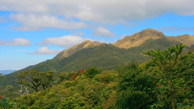
Mount Pulag is the 3rd highest mountain in the Philippines  It is Luzon’s highest peak at 2,922 meters above sea level. The borders between the provinces of Benguet, Ifugao, and Nueva Vizcaya meet at the mountain's peak.

It is the third highest mountain in the Philippines, next to Mount Apo and Mount Dulang-dulang.

Mount Pulag is famous for its majestic "sea of clouds" and the view of the Milky Way Galaxy at dawn, which has attracted many tourists who wish to see the "other-worldly" scenery.

Mt Pico de Loro (Cavite)


Mount Pico de Loro, also known as Mount Palay-Palay, is a dormant volcano in Cavite province on the island of Luzon, Philippines. The mountain is one of the ancient volcanic features of Bataan Arc


History
Pico de Loro was first named by Spanish sea-farers which means "Parrot's Beak" as its pointed summit resembles the shape of a parrot's beak from afar and it is commonly used as a signal by sea-farers to turn east to get to Manila Bay 


Under the Proclamation No. 1315 s.2007 of the Philippine government, the Mounts Palay-Palay–Mataas-na-Gulod Protected Landscape is placed under the protection and jurisdiction of the Department of Environment and Natural Resources


Pagudpod Beach (Ilocos Norte)


Pagudpud is a fourth class municipality and a coastal resort town of Ilocos Norte province, in the northern Ilocos Region of the Philippines.

 According to the 2010 census, Pagudpud has a population of 21,877 people. It is the northernmost settlement on Luzon Island and a popular tourist destination because of its resorts and beaches.


 According to the 2010 census, Pagudpud has a population of 21,877 people. It is the northernmost settlement on Luzon Island and a popular tourist destination because of its resorts and beaches.

Pagudpud was made a municipality on July 5, 1954. Unlike Laoag City, the province's only autonomous city, Pagudpud derives its authority from the provincial government. It had previously been a part of the neighboring town of Bangui.


Calinawan Cave (Tanay, Rizal)

Calinawan cave is a cave found in Brgy. Tandang, Kutyo, Tanay Rizal - it is named after the historical event where Filipino settled and agreed on their disputes between Spanish Revolutionaries, the agreement promises "linaw" a Filipino word for clarity (the bisayan word "kalinawan" means "peace" suits very well too). From what I have seen, the part that was opened for spelunking is just a small part - and yes it is, according to our guide the cave is composed of seven levels and only two were open as the others are not yet explored. The cave was privately managed until  last year (2012)when they collaborated with DOT.

Calinawan cave is a cave found in Brgy. Tandang, Kutyo, Tanay Rizal - it is named after the historical event where Filipino settled and agreed on their disputes between Spanish Revolutionaries, the agreement promises "linaw" a Filipino word for clarity (the bisayan word "kalinawan" means "peace" suits very well too). From what I have seen, the part that was opened for spelunking is just a small part - and yes it is, according to our guide the cave is composed of seven levels and only two were open as the others are not yet explored. The cave was privately managed until  last year (2012)when they collaborated with DOT.

Currently, the cave  can be toured in a 20-30 minutes walk depending on your pace, they charge 100.00 per tour guide and 20.00 for the entrance fee per head. We were nine that time and was suggested to be accompanied by two tour guides.

Batlag Falls (Tanay, Rizal)


BATLAG FALLS

Tanay, Rizal 
Height: 10 meter        s
Jump off point: Brgy. Plaza Aldea, Municipality of Tanay
Trail length: 10 minutes
Entrance fee: P20.00

Further up from Daranak Falls is its sister upstream, Batlag Falls. Set in a dense forest, with nearby tables and cottages, this waterfall is set on a unique rock formation, with the water following its unpredictable contours. This departure from the conventional picture of a waterfall, coupled with its more serene setting, makes Batlag Falls a sight to behold.

To reach it: There is a sign that says “Batlag Falls” near the Daranak Falls pool. Take the cemented foothpath which will ascend into a makeshift gate, where another P20 will have to be paid. A forest will ensue, and two waterfalls, each with a catchbasin. The smaller one, on the left, has a veil-like cascade whereas the larger one, as mentioned, has an unusual configuration. You may swim in both pools although you have to be careful as the floor of the pool is likewise unusually shaped, with sharp rocks abruptly jutting out.

You can go even further up to the origin of Batlag Falls. Here the stream is clearer. Locals tell of waterfalls deeper in the mountains of Tanay and outlying towns.